If you’ve followed my journeys over the years, you know that feeling well. You are legs-aching tired, your lungs are burning, and the false summits have been teasing you for an hour.
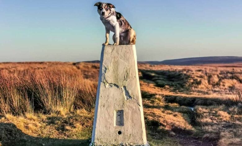
Then, suddenly, the ground levels out, and there it is. A gleaming white or grey obelisk standing proud against the sky. The Trig Point.
For us hikers in Britain, these concrete pillars are more than just navigational aids; they are old friends.
They are the silent sentinels of our summits, the finish line of our sweaty endeavours, and, let’s be honest, the perfect leaning post for a well-earned flask of tea.

But how often do we stop to think about how they got there? Or why?
I wanted to dive deep into the story of the humble Ordnance Survey Triangulation Pillar.
From their fascinating history and hidden engineering to the modern obsession of “trig bagging,” here is everything you need to know about the concrete icons of the British outdoors.
A Grand Design: What Is a Trig Point?
You might know them as “trigs,” but their official title is Triangulation Pillars.
To the uninitiated, they are just 4-foot-tall blocks of concrete. But to a surveyor—or a history buff—they are a masterpiece of design.
They were the brainchild of Brigadier Martin Hotine, a man who deserves a toast from every hill walker in the land.
In 1935, the Ordnance Survey decided that the old map system (some of which dated back to 1783!) was falling apart.
They needed a new, unified system to map Great Britain with pinpoint accuracy. Hotine’s solution was to cover the country in a web of triangles.

The “Iceberg” Principle
When you tap the top of a trig point, you are only seeing the tip of the iceberg. The classic “Hotine” pillar is designed to be immovable.
The Pillar: The bit we see. A truncated square pyramid made of cast concrete (or sometimes local stone), standing about 4 feet (1.2m) high.
The Spider: Next time you are at one, look at the brass fitting on top. That three-armed groove is called the “spider.” It was designed to hold a theodolite (a surveying instrument) perfectly in place, so every measurement was taken from the exact same millimetre.

The Roots: Crucially, the pillar extends deep underground into a massive concrete “founding block.” This ensures that frost, soil movement, or rubbing sheep don’t shift the pillar by even a fraction of an inch.
The Great Retriangulation (1936–1962)
The project to build these things was herculean. We talk about “steps” on this site—well, imagine the steps involved here!
It all began on 18 April 1936, in a muddy field in Cold Ashby, Northamptonshire, where the very first pillar was consecrated.
Over the next 26 years, surveyors hauled tons of concrete, water, and sand up the highest peaks and remotest islands of Britain.

They worked through the pre-war tension, paused for WWII (where their skills were used for radar and artillery), and returned to finish the job in the wild Scottish Highlands.
The final calculation wasn’t taken until 4 June 1962 at Thorney Gale in Cumbria.
In total, around 6,500 pillars were built. They formed the skeleton of the OSGB36 (Ordnance Survey Great Britain 1936) mapping system—the very grid references we still use on our paper maps today.
The “Vanessa”: A Scottish Special
If you hike in the Highlands, or on the Isle of Skye, you might have noticed some trigs look different. They are round, cylindrical tubes rather than the square shapes we see in the Peaks or Dales.

These are affectionately known as “Vanessas.”
Why? Because the concrete was poured into cardboard tubes made by the Vanesta company—who were famous for making toilet roll tubes!
It was lighter to carry cardboard tubes up a Munro than heavy timber shuttering, and the round shape shed the fierce Highland winds better.
The “Summit” Myth: Close, But Not Always the Top
Here is a fact that surprises many seasoned walkers: the trig point is not always the highest point of the mountain.
While we treat them as summit markers, the surveyors who placed them didn’t care about bagging the peak; they cared about mathematics and visibility.
To make the triangulation work, a theodolite placed on the pillar needed a clear line of sight to at least two other primary pillars.

If the true summit was too flat, rounded, or obstructed by nearby ground, the surveyors would position the trig slightly lower down to get the perfect view.
Helvellyn: This is the most famous example. The trig point on this Lake District giant sits on a flat plateau about 100 metres away from the true summit cairn and is actually a metre lower. The surveyors needed that specific spot to see past the bulk of the mountain to their next station.

Kinder Scout: In the Peak District, the trig point stands proudly at Kinder Low (633m), which offers firm ground and sweeping views.
However, the true summit is a nondescript, often boggy mound further onto the plateau at 636m. Most walkers are quite happy to count the dry trig point as “close enough”!

Yes Tor vs. High Willhays: On Dartmoor, Yes Tor (619m) boasts the trig point and looks like the dominant peak. However, the rocky outcrop of High Willhays next door is actually taller (621m) but has no pillar, just a cairn.
So, if you are a purist, make sure you check the map—you might need to walk a little further past the concrete pillar to truly say you’ve touched the top!
The Cult of “Trig Bagging”
The satellites eventually took over. With modern GPS, the Ordnance Survey no longer needs these concrete pillars to make maps. In fact, they now maintain the entire National Grid with just 110 active GPS stations (OS Net).
But while they are scientifically obsolete, they are culturally alive.
Enter the Trig Baggers. This is a wonderful community of enthusiasts dedicated to visiting as many of the remaining 6,000+ pillars as possible. It is a fantastic way to motivate your walking habit.
- The Rules: Generally, you have to touch the pillar. Some purists insist on a photo.
- The Legend: We have to mention Rob Woodall. In 2016, after 14 years of hiking, boat chartering, and bushwhacking, he became the first person to bag every single extant trig pillar in Britain—all 6,190 of them.
- The Tools: If you want to get involved, apps like TrigpointingUK or TrigFindAR App are essential for tracking your finds.

Some Favourite Trigs: A BaldHiker’s Selection
I have leaned on a fair few trigs in my time, usually while catching my breath! While some require a major expedition, many of my favourites are accessible, family-friendly, and offer some of the best stories in the British Isles.
1. The Artistic Summit: Moel Famau
Location: Clwydian Range, North Wales This is a hill I know well, standing as the highest point in the Clwydian Range. It’s a steep climb but the reward at the top is unique.
The Trig: Unlike the standard white pillars, the trig point here is a work of art. To celebrate the 40th anniversary of the Area of Outstanding Natural Beauty (AONB), the trig was painted by local artists with beautiful silhouettes of local wildlife—black grouse, curlew, and skylark.

The View: It sits amidst the ruins of the Jubilee Tower, an Egyptian-style obelisk built for King George III that was famously blown down in a storm. The combination of the colourful trig, the ruins, and the views over to Snowdonia makes this a must-visit.
More details can be found in our guide and walk up Moel Famau.
Another great Trig Point with art of a different kind can be found atop The Wrekin in Shropshire
2. The Historic Giant: Pendle Hill
Location: Lancashire Pendle is a hill wrapped in myth and legend, famous for the 1612 Witch Trials, but its summit holds a deeper spiritual history too.
The Walk: It’s a lung-busting climb up the “steps,” but the plateau at the top offers sweeping views over the Ribble Valley.
Take a look at my detailed walk and history up Pendle Hill.

The History: When you touch the trig stone here, you are standing on the spot where George Fox had a vision in 1652 that led to the founding of the Quaker movement. It is a place of rebellion, religion, and rugged beauty.
3. The Family Favourite: Nicky Nook
Location: Scorton, Lancashire Nicky Nook isn’t a mountain—it’s a modest fell standing at just 215m (705ft)—but don’t let the height fool you. It punches well above its weight for views.
The Walk: As I’ve written about before, this is a wonderful walk for the whole family. You can start from the village of Scorton or near the Applestore Cafe.
Read my article about a walk up Nicky Nook.

The Trig: The path winds up clearly to the white pillar at the summit. On a clear day, the panorama is stunning: you can see the dazzling Morecambe Bay, the silhouette of the Lake District fells, and even the Isle of Man. It’s the perfect introduction to trig bagging for little legs.
4. The Coastal Curiosity: Flamborough Head
Location: East Yorkshire Coast This one is for the history lovers, and it’s important to get the details right as there is a common misconception here!
The Truth: You will often hear people say the lighthouse is the trig point. That’s not quite right. At Flamborough Head, standing faithfully next to the Old Lighthouse (the incredible Chalk Tower built in 1674), you will find a standard concrete trig pillar (TP S6327).

The Experience: You get a “two-for-one” here. You can admire England’s oldest surviving lighthouse tower and bag a genuine trig point in the same spot. The rugged white cliffs and the crashing North Sea provide a dramatic backdrop that is miles away from the quiet hills of Lancashire.
5. The Highest and Lowest
Highest: Naturally, this is atop Ben Nevis (1,345m). The pillar there sits on a high stone plinth so it doesn’t disappear under meters of winter snow.

Lowest: Believe it or not, you can visit a trig point that is below sea level! The pillar at Little Ouse in Cambridgeshire sits in a ditch at -1m.
Photography: Capturing the White Pillar
We all love an Instagram shot at the summit, but trig points can be tricky to photograph. They are bright white (usually), and the landscape is often dark green or brown.
Exposure: Your camera will try to darken the image because of the bright white concrete. If you can, slightly underexpose the shot so you don’t lose the texture of the weathered stone.
Composition: Don’t just stand next to it. Try the “follow me” pose leading towards the view, or catch the “golden hour” sun hitting the brass spider on top.
The Plank: Yes, it’s a trend. “Planking” on top of a trig is a rite of passage for some baggers—just be careful if it’s windy!

A Note on Safety: GPS vs. Paper Maps
Here is a boring but critical safety tip for my fellow navigators.
The trig points created the OSGB36 coordinate system. However, your modern GPS or phone uses a global system called WGS84.
Why does this matter? In Britain, the difference between the two can be over 100 metres. If you are navigating in thick fog on a dangerous plateau (like Kinder Scout or the Cairngorms) and you plot a GPS coordinate onto a paper OS map without converting it, you could be 100 metres off.
In the mountains, that is the difference between the path and the cliff edge.
Always ensure your GPS is set to “British National Grid” when using our paper maps.
Conclusion: Touch the Stone
Why do we love them? I think it comes back to connection.
When you reach a trig point, you are connecting with history—with the sweat and toil of the surveyors who hauled that concrete up there 80 years ago.
You are connecting with the landscape, knowing you are at a point that defines the very shape of our nation.
But mostly, it is about the personal journey. Whether you are walking for fitness, for mental health, or just to escape the noise of the world, that white pillar is a symbol of achievement. It says: You made it. You are here. Take a breath.
So next time you see one, give it a pat from me. And maybe check the Flush Bracket number—you might just get hooked on bagging them!
Happy hiking, everyone.
Paul
Source link