There is a unique, brooding atmosphere that clings to the moors above Haworth. It isn’t just the wind—which Emily Brontë described as a “power” blowing over the edge—but the sheer weight of literary history etched into the gritstone.
I always find it fascinating, heading out to walk the footsteps of the Brontë sisters, taking a 7.4-mile circular route that captures the very best of this dramatic landscape.
From the cobbled streets of the village to the desolate ruin of Top Withins and back via the engineering calm of Lower Laithe Reservoir, this walk has it all: history, views, and a touch of wildness.
Here is how my journey went and everything you need to know to do it yourself.
Walk At A Glance

Starting in Haworth: Cobbles and History
The walk begins right in the heart of Haworth at St Michael and All Angels’ Church. Before you even tie your laces, the history here hits you.

The church stands at the top of the famous cobbled Main Street, and while the current building largely dates from a reconstruction in roughly 1879, the tower is much older, still bearing the marks of the 15th century.
It is impossible to start here without thinking of the Brontë family. Patrick Brontë preached here for 41 years, and beneath the church floor lies the family vault where Charlotte, Emily, and the rest of the family (except Anne) are buried.
I took a moment to wander through the churchyard before heading out. It is incredibly atmospheric, packed tight with blackened headstones.
In the mid-19th century, the sanitation here was so poor due to overcrowding—over 40,000 bodies are buried here—that it contaminated the water supply, a grim reality of the time that Patrick Brontë fought hard to improve.

Up to Penistone Hill
Leaving the church behind, I took the route that loops around the back and up towards Penistone Hill Country Park. This is where the transition happens. You leave the “civilized” village and hit the open, scarred landscape of the lower moors.
The ground here is pockmarked with craters, a reminder of the area’s industrial past. Penistone Hill wasn’t just a beauty spot; it was a hive of quarrying activity for the local sandstone (Millstone Grit).
The name “Penistone” is even thought to come from “Penny Stone,” a gambling game the quarrymen would play here, hidden away from the prying eyes of the village!
Today, it is purple with heather and dotted with bilberries, offering the first sweeping views back down the valley.

The Bronte Waterfalls and The Chair
From Penistone, I followed the Bronte Way markers, dropping down into the Sladen Valley. The path can be uneven here, with large stone flags laid to protect the peat, so watch your step.
The destination is the Bronte Waterfalls. It’s not a single giant drop, but a series of tumbling cascades that race over the gritstone steps. Charlotte Brontë once described it as a “perfect torrent” after rain, and you can see why.

Just by the falls, keep an eye out for a rock formation known as the Bronte Chair. Legend says the sisters would take turns sitting here to write and tell each other stories.
It is a surreal feeling to sit in that same spot, looking at the same rushing water that likely sparked ideas for Jane Eyre or Wuthering Heights.
Crossing the stream, I walked over the Bronte Bridge. The bridge you see today is actually a replacement; the original was swept away in a flash flood in May 1989.

The new stone slabs were flown in by an Army helicopter to rebuild it—a testament to how wild the water can get here!
The Climb to Top Withins
After the bridge, the real work begins. The path climbs steeply out of the valley up to the high moor. It’s a lung-buster for those on the tourist trail, but the expanding views are worth every step.

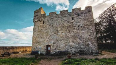
Eventually, the ruin of Top Withins appears on the horizon. Sitting at around 1,400 feet, this abandoned farmhouse is widely accepted as the setting for the Earnshaw family home in Wuthering Heights.
A plaque on the wall admits that the building itself doesn’t match the grand house in the book, but the desolate, windswept location is absolutely perfect.

I always find it wonderful up here when you get the place to yourself. With the literary history laid out before you it is easy to relax for a while up here, and be inspired yourself.

One of the most fascinating things up here is the signage. You will spot waymarkers in both English and Japanese. The Brontë novels are huge in Japan (where Wuthering Heights is known as Arashi Ga Oka or “Hill of Storms”), and this ruin is a major pilgrimage site for Japanese literary fans.

The Return: Stanbury and The Reservoir
From the ruins, I picked up the Pennine Way for a short stretch before turning towards the village of Stanbury. This part of the walk feels different—you are coming down from the wild “tops” into the intake farmland.
Stanbury itself is a lovely linear village of stone cottages clinging to the ridge. I walked past the Wuthering Heights Inn. It wasn’t always called that; back in the Brontés’ day, it was the Cross Inn, and Patrick Brontë would have known it well.
It was renamed in the 1980s to nod to the tourists, but it’s still a cracking traditional pub with a log fire if you need a mid-walk pint!

Leaving Stanbury, the route drops down to Lower Laithe Reservoir. The scale of the dam is impressive, and the walk takes you right across the top of the embankment.
The reservoir was finished in 1925, delayed significantly by World War I. As you walk across the dam, look up the valley; the water covers what used to be the bottom of the Sladen Valley, submerging farms and a mill.
It’s a peaceful, engineered contrast to the wild moors you’ve just come from.

Back to Haworth
The final leg is a push back up the hill, rejoining the road to head back into Haworth. Ending the walk where I started, near the Parsonage, really brought the whole experience full circle.
You can look back out the windows of the museum and visualize exactly where those three sisters walked, seeing the landscape that shaped some of the greatest literature in the English language.
If you are ever in West Yorkshire, this 7.4-mile loop is an absolute must. Just don’t forget your boots—it gets muddy up there!
Source link